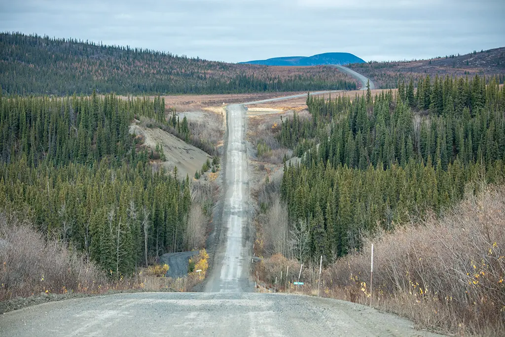
The Dempster Highway is one of the most unique and challenging road trips in Canada, taking adventurers deep into the wild landscapes of Yukon and the Northwest Territories. Stretching 740 kilometers (460 miles) from Dawson City, Yukon, to Inuvik, Northwest Territories, this all-gravel highway is Canada’s only road to the Arctic Circle. Unlike other highways, the Dempster Highway Canada offers stunning mountain views, vast tundra, and incredible wildlife, making it a bucket-list journey for those who love off-the-grid travel.
If you’re looking for a true northern adventure, this guide will cover everything you need to know about driving the Dempster Highway, including what to expect, top stops along the route, and essential travel tips.
Table of Contents

1. Where is the Dempster Highway?
This Highway begins near Dawson City, Yukon, at Kilometer 0, and stretches all the way to Inuvik, Northwest Territories. It crosses through some of Canada’s most remote landscapes, including mountain ranges, Arctic tundra, and two major river crossings before reaching its northernmost point.
Did You Know? This Highway was built in the 1950s as a supply route for oil exploration. It officially opened to the public in 1979 and remains one of the last true wilderness highways in North America.
2. What to Expect on the Dempster Highway
The Dempster Highway Canada is a completely unpaved, gravel road, known for its rough conditions, unpredictable weather, and stunning scenery. Unlike other highways, it has no major towns along the way, only small outposts and remote lodges.
Key Features of the Dempster Highway:
- Gravel & Dirt Surface – Expect dusty or muddy conditions, depending on the weather.
- No Cell Service – The entire highway is off-the-grid, with no mobile reception.
- Limited Fuel Stops – Only available at Eagle Plains (KM 369) and Fort McPherson (KM 555).
- Wildlife Sightings – Spot caribou, moose, grizzly bears, and Arctic foxes.
- Scenic Landscapes – Drive through mountains, tundra, and vast Arctic wilderness.
Tip: Due to the high risk of flat tires, travelers should carry at least one full-size spare tire, extra fuel, and emergency supplies.
3. Best Stops Along the Highway
While the Dempster Highway is remote, there are several must-visit stops along the way.
Tombstone Territorial Park (KM 74)
One of the most scenic areas on the Dempster Highway, known for its dramatic mountain peaks, hiking trails, and wildlife viewing.
Eagle Plains (KM 369)
A crucial stop for gas, food, and accommodations. Also home to the famous “Welcome to the Arctic Circle” sign at KM 405.
Fort McPherson (KM 555)
A Gwich’in First Nation community where travelers can learn about Indigenous culture and history.
Tsiigehtchic (KM 606)
A small settlement at the Mackenzie River crossing, with incredible river views and cultural experiences.
Inuvik (KM 740)
The final stop on the highway, a unique Arctic town with Indigenous culture, northern lights viewing, and access to the Arctic Ocean.
Tip: Be sure to stop at the Arctic Circle sign (KM 405) to take a photo—it’s one of the most iconic moments on the drive!
4. Wildlife on the Dempster Highway
One of the best parts of the Dempster Highway is the incredible wildlife you can see along the way.
Animals You Might Encounter:
- Porcupine Caribou Herd – One of the largest caribou herds in North America migrates through the area.
- Grizzly Bears & Black Bears – Often seen near the highway, especially in the summer.
- Arctic Wolves – Rare but sometimes spotted hunting in the tundra.
- Red & Arctic Foxes – Frequently seen near the road.
- Golden Eagles & Peregrine Falcons – Common in the open wilderness.
- Beavers & Muskrats – Found in the rivers and marshlands along the highway.
Tip: The best time to see wildlife along the Dempster Highway is during early morning or late evening when animals are most active.
5. How to Prepare for the Dempster Highway
Because the Dempster Highway is long and remote, proper preparation is essential.
What You Need to Bring:
- Spare tires & repair kit – The gravel road is tough on tires.
- Extra fuel – The only gas stations are Eagle Plains and Fort McPherson.
- Food & water – There are very few restaurants or stores.
- Camping gear – If you plan to stay overnight in the wilderness.
- Emergency supplies – First-aid kit, blankets, and survival gear.
Tip: Always check weather and road conditions before starting your journey. Heavy rain can make the road slippery, and snow is possible even in summer.
6. Best Time to Drive the Dempster Highway
The Dempster Canada is open year-round, but the best time to visit depends on what you want to experience.
Best Seasons for Travel:
Summer (June–August): Best for road conditions, wildlife, and hiking. Expect 24-hour daylight in late June!
Fall (September–October): Incredible autumn colors and the best time to see the Northern Lights.
Winter (November–March): Extreme cold and snow, but amazing Aurora Borealis displays.
Spring (April–May): Mud season as snow melts—less ideal for driving.
Tip: If you want to see the Midnight Sun, visit between late June and early July. For the Northern Lights, September is the best time.
7. Why You Should Drive the Dempster Highway
The Dempster Highway is more than just a road—it’s a journey through some of Canada’s most remote and breathtaking landscapes. Whether you’re an experienced traveler or someone seeking solitude in nature, this highway offers an unforgettable adventure. From driving through untouched Arctic wilderness to witnessing the Midnight Sun and Northern Lights, every mile presents a new wonder. Along the way, you’ll have the chance to spot rare wildlife like caribou and Arctic foxes and even cross the Arctic Circle, a rare experience for any road trip. As one of Canada’s last true off-the-grid adventures, the Dempster Highway Canada promises a road trip like no other.
Ready to explore? Start planning your journey today!